The drive from Phoenix to the Sedona area was 115 miles, a good portion of it mountains. Before the accident, I don’t think this stretch of I 17 would have bothered us, but we were just a bit tense now. There is still snow on the north sides of the mountains from the storms a week or two ago.
Montezuma’s Castle and Well never had anything to do with the great ancient Aztec leader in Mexico, but apparently some early explorers thought these cliff dwellings were connected somehow. Imagine the Sinagua Indians building and living in these walled-in caves on the sandstone cliffs.
Montezuma’s well is a spring pouring 1.5 million gallons of 74 degree water a day from a deep sinkhole on a plateau. The water then runs from the pool underground to emerge on the hillside into an irrigation ditch the Sinagua built to water their crops. It is a sacred place to the Hopi, the people who probably absorbed the Sinagua when they abandoned this area. It’s a truly serene, beautiful place.
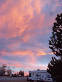
We stayed several nights at Western Horizons, another Camp Club USA park, where we played shuffleboard one evening during a sunset in the round. I don’t think I have ever seen a sunset go 360 degrees all the way around the horizon. It was phenomenal.
We camped the rest of our Sedona time at Dead Horse Ranch State Park where we had five miles of road to bike. Tuzigoot is another Sinagua site, this one a hilltop complex of 86 rooms overlooking a rare Arizona marsh where the Indians probably found rich food and products for living.
Jerome is a mining ghost town come back to life. It is perched high on the mountainside with every street a switchback from the previous block.
This mine shaft is 1900 feet deep.
We have said to each other that the desert has its magical beauty, but we would not want to live in it. I could live in Sedona though. The higher elevation (4400 feet and up from there) and more rainfall mean trees can grow—real forests of them. I am in heaven. The red rocks are amazing. We did a 2 ½ mile hike that nearly did me in. But it was gorgeous with the blue agave and evergreens set against the red spires and blocks of stone.
After this, I think those trails in the Kettle Moraine that Don said were too rocky will be a piece of cake. This formation is called Cibola, the mitten in Spanish.
Oak Creek Canyon is a drive north of Sedona that rises above 6000 feet. The switchbacks to get to the Mogollan Rim, the top of the canyon, were . . . invigorating.
I bought a turquoise ring from one of the Hopi sellers at the top.
Bell Rock proved too much for Don. I lost the trail on the rock, but found my way back down the solid rock layers. If you click on this picture, you will see little things up there that are people. I did not make it all the way up.
We had some quiet prayer time in the Chapel of the Holy Cross on the mountainside.
In case anyone wonders about our safety driving after our accident and new rig, let me tell you about our drive today. We drove north from Sedona and then west on I 40. The trees of the Flagstaff area mountains gave way to wide-open flat desert. I could feel the wind as I drove and saw the few bushes blowing. I watched the camper carefully—no sway. When we stopped near Meteor Crater and stepped out of the truck, the wind hit us like a gale. Unbelievable wind—but the truck handled the camper just fine.
Meteor Crater is a hole in the ground from a long ago meteorite 150 feet across weighing several hundred thousand tons. It blasted 175 million tons of sandstone up to a mile away. The crater is nearly a mile across and 550 feet deep. Just amazing.
The biggest meteorite fragment they found weighs 1400 pounds.
Another Arizona sunset


Jean the pictures on your blog are wonderful. Enjoyed reading about your trip. Hope to see you this summer when you return...
ReplyDeletePeggy
Thanks. Maybe you can come to one of the KMS luncheons. Or come up to the lake. We like having guests on the pontoon.
ReplyDelete